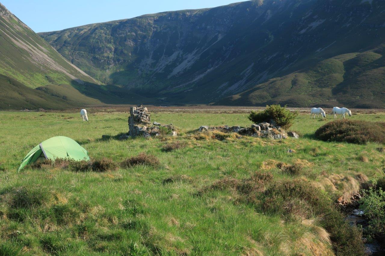

As far as meeting places go, I guess it was pretty unusual. When I arrived I was first greeted by three beautiful white horses, nonchalantly eating grass among the ruins.
I didn’t have to wait long before my group arrived, still seemingly full of energy and enthusiasm after a long walk up Glen Feshie.
The reason I was here was, ostensibly, to help out with supervising a group of Duke of Edinburgh Award students from Inverness Royal Academy. But, as I wasn’t officially one of the required number of supervisors, I was able to use the opportunity to get onto the hills on this wonderful summer’s day.
We had arranged to meet on the west side of Glen Feshie, so the Munros to the east were not an option, as it is usually impracticable to cross the river safely. So, checking the map beforehand, I settled on the Corbett of Carn Dearg Mor, which rises to 857m and is directly above where we planned to meet.
Starting at Feshiebridge, I donned the overnight rucksack and took the mountain bike down the right of way signed towards the “Glen Feshie road (west side)”. It follows a lovely track through open woodland then into a field where a sign warns that cows, calves and bulls are kept. They were well away from the track on the way in, though, and I soon arrived at the road beyond the house at Ballintean.
")
")
")
The public road continues for another mile or so beyond here to a bridge, from where the well-made estate road takes you deeper into Glen Feshie. Soon it turns to a surfaced road as well, making for an easy ride with great views over the river to the high mountains.
You also get a sense of a land full of life. The estate here controls its deer numbers to allow the Caledonian forest to regenerate, and you can clearly see young trees growing naturally among the older Scots pine as well as a healthy ground level, brimming with heather and wildflowers.
I left the bike well hidden under an adolescent tree at a track junction just before the cottages at Carnachuin to make the rest of the journey on foot. Following this track north-north-west up the steep hillside, the view across the glen soon started to open up even more.
At around the high point of the track, I turned south to gain the ridge, which proved a minor battle as I had to fight my way through a pathless mass of heather interspersed with the occasional bit of bog as I aimed from crag to crag.
It wasn’t long before I reached better walking ground, though, and it was straightforward to follow the ridge line in these conditions. The ridge then steepens before levelling again to a trig point on top of Carn Dearg Beag.
It was a spectacular place to be on a day like this. Across the glen I could see the track climbing up the hillside towards the Munro of Mullach Clach a’ Bhlair and in the distance I could just make out the tops of what I think were Cairn Toul and Braeriach.

At my feet as I met the track climbing up to the Corbett were some wonderful wildflowers which I later learned were cloudberries. These plants (pictured above left), a relation of the raspberry, grow plentifully in Scandinavia and were once a traditional food in parts of the Highlands. The Gaelic name for them, oighreag, still lives on in place names including Beinn nan Oighreag above Glen Lyon in Perthshire.
Before I reached the summit I came across something even more unexpected – a rusty old peat-cutter standing, dug into the earth at the side of the track. It looks like it could have been in this position for years!

Soon I was at the summit cairn and, with plenty of the day left, I wondered about extending my trek to another Corbett which lies a couple of miles south of here, Leathad an Taobhain.
Its high point is only two metres short of Munro status and it sits directly above the summit of the Minigaig pass.
But with my water just about empty and little to no flow in the burns up at this height, I had to descend just to quench my thirst. The path drops to a bealach then steeply down to meet a better track which I followed left.
Even the burns here were dry, so I headed down the Slochd Mor, pausing for a break at the delightful Lochan an t-Sluic before aiming for our meeting point at the ruins of Ruigh-fionntaig, filling the water bottle on the way.

The ruins here are the remains of a 19th-century shooting lodge and kennels, with a number of mainly wooden houses, but there is evidence of people living here from medieval times with rig and furrow cultivation discovered in the immediate vicinity.
Now it was just me and the three horses, until the DofE group arrived.
We made our camps – my tent pitched in among the ruins near the burn where I enjoyed a good night’s sleep after exploring the glen with the teachers in the evening (and discovering that the river was so low it was easy to cross at the moment).
")
")
On the way out the next day, we met the estate keeper, who told us the horses are there simply because the laird likes them being there. They were clearly well cared for, in fine condition and happy to spend their time in this wonderful place.
As I made my way back to my bike, we passed the site of the old Carnachuin bridge, which was washed away in 2009 and has still not been replaced due to a planning wrangle between the estate and the national park authority.
The timber is still lying there on the opposite side of the river, waiting for the bridge to be repaired and replaced. It is such a shame that no progress has been made on this important crossing, though the estate has helpfully signed the bridge near Achlean as the last crossing over the Feshie for walkers and other access users in the meantime.
Uncovering the bike, I said goodbye to the group and enjoyed a fine ride in the early morning sunshine, detouring via Drumguish on another right of way before returning to Feshiebridge via the Badenoch Way and Uath Lochans.
Route details
Carn Dearg Mor, Glen Feshie
Distance 9.5 miles / 15km total walking plus 7 miles / 11km ride each way (direct route from Feshiebridge)
Terrain Estate tracks and road on bike; tracks, pathless onto ridge and over much of hill; navigation skills required
Start/finish Feshiebridge
Maps OS Explorer OL56 & OL57; OS Landranger 35
Exploring Glen Feshie by bike and on foot