
Perched in the entrance of the tent, I watched as a golden eagle soared majestically over the head of Glen Bruar, its wing tips glinting as the sun sank slowly behind the hills.
It had been a long day, trekking 18 miles through some challenging terrain with an overburdened rucksack on my shoulders.
Despite my exhaustion, the eagle reminded me of all the wonderful things I had seen – from an adder slithering through the heather at my feet to newts, frogs and even frogspawn.
The fast-melting snow has left the mountains saturated – where it isn’t still lying – providing plenty of pools for the emerging wildlife to thrive.
The remaining snow was causing problems for me, though. Several detours were needed despite the protestations of my tired legs and shoulders.
I began my walk at Kingussie – not Blair Atholl as I had planned but that’s another story. As the train pulled away I crossed the railway and followed the road towards the ruins of Ruthven Barracks.
The prominent garrison was built between 1719 and 1721 following the 1715 Jacobite uprising on the site of the medieval castles of the Comyns and the Gordons.
It was the route of the soldiers who were stationed there that I was going to follow through the hills.
The Minigaig pass was one of the earliest routes to the north – superseding Comyn’s Road in the 17th century – and was still in use when General Wade ploughed his military road through Drumochter.
The unmarked right of way starts at a gate 50 yards before the barracks and heads up alongside fields to follow a grassy track up through a small wooded glen to a ruined barn.

I clambered over the stile and onto the open hillside, where a track led up into the moors. I followed it almost to the crest of the ridge then forked right at a cairn on a route that was just about visible through the heather.
This eventually led to a clearer track that went round the back of a craggy rise before forking and disappearing into the surrounding grouse moor. In the absence of the path marked on the map, I made a beeline for the shallow bealach below Sron na Gaoithe.
From here I followed a rough line down its south ridge past Carn Pheigith – a memorial cairn to someone called Peggy or Margaret – aiming for the Dailriach Bridge over the River Tromie.
My first major obstacle was a fairly new deer fence around a regenerating bit of woodland in the glen. I got down to the fence and followed it until I found a gate – it even had the first Scottish Rights of Way Society sign I had seen on the route so far; a reassuring sight!
I closed the gate behind me and followed a nice little path down to the bridge – or at least to what was left of it. I now had the River Tromie between me and my continued route to the Minigaig.
The river looked fierce as it crashed between the rocks below the derelict foundations, so I bashed my way through the trees along the bank. Where the river was wider it looked a little less daunting but it was still flowing at a fair rate and there were unavoidable deep sections almost everywhere.

As I started taking my boots off in preparation for an unplanned crossing, the gamekeeper came driving up the road through Glen Tromie on the opposite bank.
He stopped and I asked if the other bridge – marked a mile or so upstream – was still there. “They’ve all been washed away,” came the not very helpful answer before he drove off!
There was nothing for it – I would have to wade.
I carefully made my way across, reaching for an overhanging tree branch as I neared the far side where the water was at its deepest.
Clambering up to the roadside, I sat, soggy and tired, on the verge, tipping my boots upside-down as the water poured out of them. Wet feet for the rest of the weekend then.
An easy stretch followed as I plodded along the private road up Glen Tromie for a few miles.
The Gaick and Minigaig routes split just before a bridge over the Allt Bhran. I looked for a path beside the bridge but I think the route starts a little further back, climbing high above a gorge before dropping down to the burn, though exact route-finding is far from straightforward up this little glen.
I reached the dam for a well-earned lunch break, conscious the real climb to the pass was yet to come. The path beyond here was not always obvious, so I kept a close eye on the map to ensure I was fording the right burns and sticking to the route, with human boot prints and even the occasional bike tyre mark reassuring me I was still on track now and again.

Having filled my water bottle from the Alltan Creagach, I made my way slowly onto the slope below Leathad an Taobhain, a remote and high Corbett – just two metres off gaining Munro status. The challenge of ascending the Minigaig was proving a big enough task for me today, so no thoughts of bagging the summit even entered my head, though it is only short detour from the highest point.
I painstakingly slogged up the waterlogged slope, understanding why the Minigaig was marked on 18th century maps as a “summer road to Ruthven” – snow still lined the route even late into April. Ahead, corniced snow hung ominously over Coire Bhran.
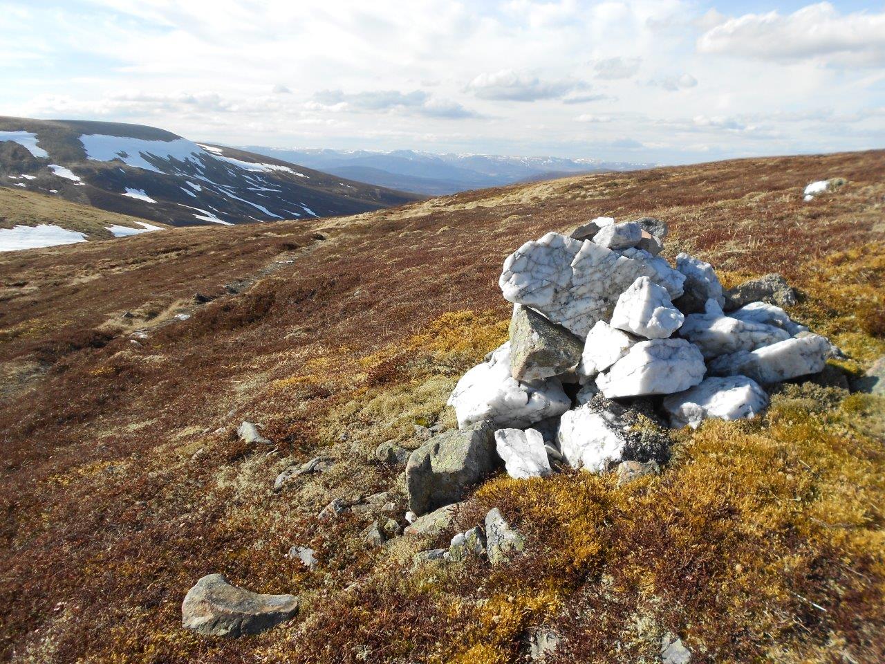
Yet there were increasing signs of an actual route to follow and, as I neared the easing of the gradient shortly before the summit, a clear track emerged. It was with some sense of satisfaction I reached the white quartzite cairn that marks the Minigaig – it should be largely downhill from here to my planned camp in Glen Bruar.
Small cairns even led the way down the much-improved path, though huge snow patches hampered easy progress, especially where they fell away into steep-sided gorges. Crossing the Caochan Lub also proved a minor challenge but, once round the worst of the snow, I regained the path below Uchd a’ Chlarsair and followed it until I could see the glen far below.

At last! I stopped for a drink and a break, admiring the dramatic view and the waterfalls pouring in from all directions.
The last battle was to descend the steep slope into Glen Bruar, fill the water bottles and find a suitable place to pitch my tent.
The sun still hung over the tops of the crags as I settled down with the stove on, utterly exhausted. Then, above me, appeared the unmistakable sight of the eagle – and all the effort seemed worthwhile.
I sat, alone in this stunning location, with such a magnificent bird for company. It had been a tough day but the hardest bit of my journey was over. The stars began to come out as darkness fell and I stayed awake long enough to admire the distant universe before falling asleep in no time.

The next morning I packed up and, after breakfast, began the slow plod down the glen, enjoying the easy walking to loosen my aching muscles. The gamekeeper was out and about before I reached the lodge and there were people in boats on the dammed river.
A very vague path makes its way from just before the bridge over the Bruar Water onto the shoulder of Druim Dubh before fording the Allt Sheicheachan to reach the bothy.
I’d been here before – on a mountain bike circuit from near Blair Atholl – so I knew the route ahead was straightforward and mostly on good tracks, as long as I could get over the burn without any problems.
Thankfully it was easy to cross, and I paused for a long break at the bothy, enjoying reading others’ tales of adventures before adding my own.
Many people stay here to reach the Munro of Beinn Dearg – which I had wanted to include on this trip but didn’t have the energy or the time to manage now.
I continued along the track, initially up away from the burn then down the last few miles towards Old Blair, then took the road through Old Bridge of Tilt to reach the village, turning right to reach the railway station.
With an hour until my train was due to take me back to Inverness, I enjoyed a fine ale or two in the Atholl Arms Hotel next to the station. It had been an arduous journey but memorable in so many ways.
Route details
Minigaig pass
Distance 29 miles /46km
Terrain Navigation and wild camping skills required, pathless mountain route with some tracks and intermittent paths, river crossings (note, the River Tromie crossing can be avoided by starting at Tromie Bridge on the B970)
Start/finish Kingussie/Blair Atholl railway stations
Maps OS Explorer OL49, OL51 and OL56; OS Landranger 43, 42 and 35
Following the historic Minigaig route – shown on Greene’s 1689 map and Moll’s one of 1725 – through the remote Cairngorms
TENT REVIEW
Vango Blade Pro 100 plus Blade 100 Footprint
Tent: £120. Footprint: £20
http://www.vango.co.uk/gb/tents/2024-blade-pro-100.html
After a long day in the hills, I enjoyed a good night’s sleep in the one-person Vango Blade. Even being exhausted and not fully familiar with the tent, it still pitched really quickly – the blurb suggests a pitch time of eight minutes and, to be fair, it probably wasn’t far off that.

Thankfully the weather was dry because it goes up inner first, which I’m not usually a fan off. I prefer to get the outer up, dump the gear under the waterproof shelter and then sort out the inside.
However, the Blade uses a single pole that clips in at either end, then you peg the corners out, clip the outer on in a few places and hook it over the same corner pegs before adding the extra pegs and guylines.
I also used the footprint – invaluable if you want to stay dry with any tent, as well as helping to protect your groundsheet – which adds 0.23kg plus six pegs needed (not included).
I’m used to having a bit more room in the entrance but backpacking means you have to compromise somewhere. The Blade – weighing in at 1.82kg (1.63kg without the bags and “extra” pegs) – does have a small porch that can roll up either side, or both, leaving room to dump gear, though not much for getting in and out once it’s all there!
There’s a handy pocket on the outside of the inner tent, useful for shoving the tent bag if you’re carrying it.
")
")
")
There are also a couple of mesh pockets inside the inner at the top, as well as one on each side at ground level, and a light hook front and back.
The flysheet has a hydrostatic head rating of 5000mm, with the groundsheet and footprint at 6000mm, more than enough to cope with some heavy downpours. The updated Blade for 2018 has a ripstop flysheet which Vango says gives it 13 per cent more strength.
The Yucan Eco Alloy pole is light and strong, though it does slip slightly off centre if you don’t get the tension in the guylines perfectly even. Those guylines are good – with Vango’s Line-Lok system which makes them easy to adjust and lock off, and they also have a reflective finish.
The tent was well ventilated, with only a small amount of condensation apparent in the morning, and it packs up very easily into its oversized bag.
All in all, I found the Blade to be a great little tent and will certainly be using it again on backpacking and bikepacking trips.
I enjoyed reading about your minigaig adventure. It’s one I’ve been thinking about for a while.