There must be easier ways to bag your 100th Munro but I’ve never been one for doing things the easy way. After a week staring out of the office window at glorious sunshine and blue skies, I set out on this weekend adventure through the Cairngorms on the most dreich of days.
Within an hour I was seriously considering the possibility of turning around, going back to the car and driving home. I hadn’t even reached the Ptarmigan restaurant on Cairn Gorm, the first of eight Munros I was planning to climb on this ambitious weekend.
The Cairngorms 4000ers is a big enough backpacking challenge, taking in Cairn Gorm, Ben Macdui (the second highest mountain in the UK), Cairn Toul, Sgor an Lochain Uaine (better known as the Angel’s Peak) and Braeriach.
Having climbed all these hills before, with the exception of Cairn Toul, I decided to include a few new Munros to my route, just to add to the equation. Bod an Deamhain – the Devil’s Point – is easy enough to add to the round, but if I could do an out-and-back to Derry Cairngorm and nip over Carn a’ Mhaim at the end of day one, that would give me four new Munros over the weekend.
Four was the magic number for me, as I was sitting on 96 Munros at my last count (not that I am counting, you understand), so that would take me to 100 – a nice achievement whether or not I go on to complete the list.
But the pouring rain had me soaked before I’d made much progress, my approach gloves sodden and the wind whipping through my minimalist two layers that I’d started out in. I donned a mid-layer and decided it was too early in the weekend to switch to my only other pair of gloves.
I plodded upwards, lost in my own thoughts and contemplating another way down from the Ptarmigan should I give up when I get that far. “Morning!” The voice leapt out of the rain as though from another universe. A female runner bounding past. We met up again as we both sought shelter in the lee of the restaurant’s walls, a last hiding place from the elements before we would leave this incongruous manmade box and head into the hills for real.
The summits – Cairn Gorm, Derry Cairngorm, Ben Macdui, Carn a’ Mhaim, Bod an Deamhain (Devil’s Point), Cairn Toul, Sgor an Lochain Uaine (Angel’s Peak) & Braeriach
We chatted and told each other our plans. It felt like a commitment to me. I would continue my journey. She passed me again on the staircase to the summit and I saw her outline head off to the north-east as I approached the massive cairn at the top. She would be home and dry before I reached my next summit.
Sheltering behind the weather station a few yards further on, I changed into my dry gloves and immediately felt better – despite the snow shower that now greeted me. I could barely see back to the summit cairn, so took a bearing off the top and dropped down towards Coire Raibeirt. A fellow backpacker was heading in the opposite direction, on her way out as I was going deeper into the mountains.
It had been probably 10 years since I’d used this particular route, and the path down the steep drop to the Loch Avon basin has been massively improved, though it still required concentration. I carefully made my way down, below the cloud now, crossing the Allt Coire Raibeirt before stopping for a break at a huge boulder overlooking the Shelter Stone Crag. I watched a distant lone figure climbing the path up to Loch Etchachan, where I was heading next, as I ate and drank and breathed in the wild surroundings.
Water was fairly pummelling down the Feith Buidhe, making the river crossing less straightforward than I’d remembered, though it didn’t involve getting wet feet in the end, thankfully. By this point the rain had been so immersive that my normally reliable camera was out of action due to the water ingress, so I used the waterproof GoPro as a backup. I was glad I had something to record this adventure on.
From the outflow of the mesmerising Loch Etchachan, I headed up the path towards Macdui, timing my ascent to work out where to break off to pass around the western edge of Creagan a’ Choire Etchachan and onwards to Derry Cairngorm. This was virgin territory to me and with zero visibility I was on the compass and checking the contours to make sure I was heading in the right direction.
The video
The rocky summit was a welcome sight after clambering across the boulder field on top of the 1155m Munro. Returning the way I came, I picked up some sort of path that led west then south-west to gain the ridge above the cliffs. I followed the ridge itself for a while then decided to drop lower down, away from the edge, knowing there was a good path that led past the lochan before the summit plateau of Ben Macdui.
There was plenty of grey up here in the cloud but no sign of the Grey Man – or any other man or woman for that matter. Again, I double-checked the direction with the compass and felt that relief of seeing the Sappers’ bothy on the approach to the summit. The Royal Engineers were based here for months in 1846, making observations and calculations as Britain was mapped in detail for the first time.
Keeping on the same line, the summit trig point soon emerged from the cloud. Munro number three had been reached and in some testing conditions. The descent would be trickier though, with some accurate nav needed to find the right route down to the bealach below Carn a’ Mhaim.
I reversed my route to the summit until I reached the flatter ground to the east, then paced on a bearing to the top of the ridge the other side of the Allt Clach nan Taillear. From here I took an aspect of slope bearing to confirm my position and a directional bearing aiming for the large flat bealach 400 vertical metres below.
The terrain is steep and rocky, with patches of large boulders to negotiate. Between picking a route through these, being put off by some glimpses of land and snow patches across the Lairig Ghru and not concentrating 100% on the compass, I ended up slightly off course. I realised my mistake as the ground was getting steeper with no sign of it easing to the bealach and I could make out what I realised was the Allt Carn a’ Mhaim below.
I traversed round to where I should have been and discovered later, when studying my route from the comfort of home, that I’d realised my error around 20 vertical metres above the level of the bealach – just in time to stop it becoming a more serious issue involving some re-ascent! Lesson learned: trust the compass and stay focused.
Taking a breather at the bealach I had a decision to make: continue the descent into the Lairig Ghru and the couple of kilometres walk to Corrour bothy or the ridge to Carn a’ Mhaim, over the other side and the long walk round the base of the mountain to the bothy.
Back up into the cloud I went, waiting for the “arete” referred to in some descriptions of this ridge, though the narrow section was short-lived and straightforward, a path meandering between some rocks. Maybe the fact I couldn’t see the steep drop on either side reduced the sense of exposure a little.
The summit was soon reached, the fourth Munro of a long and wet day and the fourth cloud-shrouded summit photograph! I continued south-east past the lower top and eventually picked up a path that dropped off the side of the mountain, though the long descent was hard on the legs by this time. It eventually met the path that reaches the Lairig Ghru from Derry Lodge, and I turned right for the last few kilometres to my overnight stop.
This was hard going but thankfully the rain had eased now and, after 19 miles and a good amount of ascent, as well as some concerted focus on the navigation, I was glad to reach the bothy and pitch my tent.
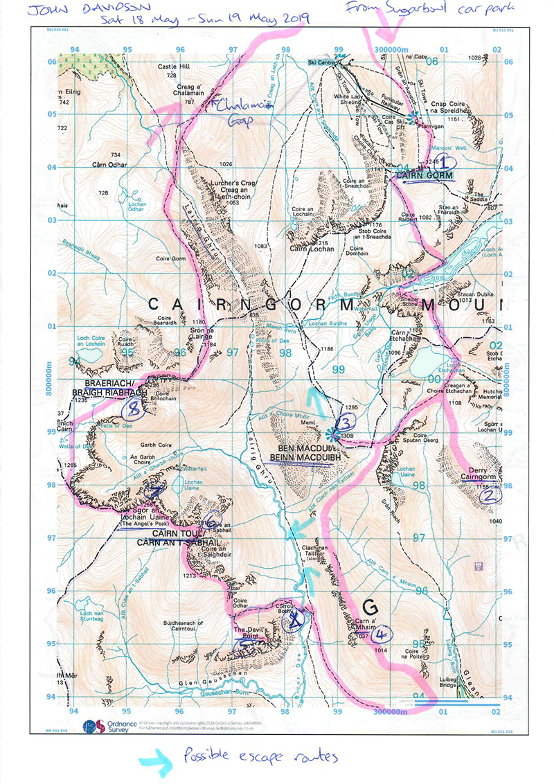
The route plan
It was busy here and tents crowded around the small shelter, which benefits from a basic eco toilet added to the gable end of the bothy. More people arrived as the evening went on, creating a temporary thriving community out here in the wilds. After a good feed and a few mouthfuls of whisky, I was ready for sleep.
The next morning, I think I was the only person heading up to the plateau, as most made their way through the Lairig Ghru or out to the Linn of Dee. My route took me up into the cloud again, rising into Coire Odhar and onto the bealach below Bod an Deamhain, the Devil’s Point.
My plan for the day was to climb the four Munros on this high ridge before making my way back to the Sugarbowl car park at Glenmore. I would use the compass and calculate my timings in small stages to keep on track of progress and navigation.
The first ascent to the Devil’s Point was a short climb through scattered rocks and occasional vegetation, ending on a prominent summit which must have a magnificent outlook on a clear day. My fifth Munro of the trip followed the same pattern as yesterday, though, so I took a quick picture and turned to retrace my route to the bealach.
Little more than an hour had passed since leaving camp this morning, and I was now making my way in the right direction, climbing initially north before the ridge bends west to pass the subsidiary top of Stob Coire an t-Saighdeir. The way was full of boulders, with only intermittent paths linking them together, but keeping an eye on my timings and using the edge of the cliffs as a handrail, progress was steady.
Another rocky descent took me to the bealach below the second Munro of the day, Cairn Toul. This would be my 100th Munro and my last ‘new’ hill of the weekend. Clambering over boulders the ascent was slower but satisfying, and I reached a cairn on the edge of the east ridge, bearing west-north-west to reach the true summit.
My spirits were high despite spending the best part of a day and a half in the cloud, and as I carefully made my way down to the next bealach I enjoyed some views into the captivating Coire an Lochain Uaine. A decade or more ago I had climbed Sgor an Lochain Uaine – my next Munro today – by its north-east ridge, an exposed but technically straightforward scramble that tops out right on the summit.
When I reached the cairn this time it was hard to see how that ridge offers a route onto the top of the so-called Angel’s Peak, – any way off the top seems to just drop down into the great abyss below. Another Munro done and just one to go now, though a serious distance still lay ahead of me.
The terrain becomes somewhat easier from here and as I made my way down I bumped into a lovely older couple who were touring Scotland bagging the lady’s last few Munros. We chatted for a long time, sharing experiences and plans, the cloud occasionally lifting now and providing a view for us to appreciate.
As we parted company, the man shouted back: “Enjoy the other 182!” We’ll see…
My next target was Carn na Criche, where the ground levels into what can be a confusing and featureless plateau. I was lucky to be enjoying some better visibility now but still used the compass in case the cloud came back in. From the cairn at the south-west edge of Carn na Criche I took a bearing across the outflow from the Wells of Dee – the remarkable source of the mighty River Dee – and filled up my water bottle with this most pure of water as I crossed.
More photos from the expedition


 and the Lairig Ghur from Braeriach summit.")


The burn fell rapidly through snow tunnels and it showed no reluctance to reach the Falls of Dee that plummet into the mighty Garbh Coire before joining the River Dee in the Lairig Ghru. Once over the burn I took a bearing to the cliffs beside the summit of Braeriach, my final Munro of the weekend. Sticking to it like glue, I had one of those satisfying mountain moments as I climbed the last few metres and saw the giant summit cairn directly in my direction of travel line.
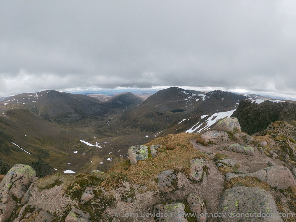
A small group of visitors were at the summit and the cloud was rising, offering me my first summit view of the weekend – and what a one to save it for! From Braeriach I stood and looked across Coire Bhrochain and the Garbh Coire down into the Lairig Ghru. I could see people on Ben Macdui, figures reaching the Angel’s Peak and the ridge to Carn a’ Mhaim stretching away in the distance.
It felt like just reward for my efforts of the weekend, though it’s fair to say the effort wasn’t over. It’s a long walk out from Braeriach and I remember suffering the last time I had come this way after that scramble years ago. It was no different today, as me feet began to feel the pain of walking in soggy socks for two long days over unforgiving terrain.
I slowed my pace, involuntarily, as I plodded over Sron na Lairige and eventually down into the Lairig Ghru itself, a steep and punishing descent that is made all the tougher by the sight of the climb back up to the Chalamain Gap ahead. I distracted myself looking at the abundance of flowers coming into bloom, including the delightful cloudberry, and took a break at the burn where the paths meet.
Once up and through the Chalamain Gap it wasn’t far to go to reach the end of the walk and a memorable excursion through these mighty and magnificent mountains. I didn’t come to conquer but to spend time among them, not taming them but understanding them, testing my skills on their resolute forms and enjoying time in this wild, beautiful land.